
Technical article · Part 3 of 3
Dipl.-Ing. David Mauro, Geospector Munich – article series “Stormwater retention facilities on federal highways”
This article series presents the stormwater retention facilities along Germany’s federal highways, how they work and the challenges involved in operating them. The third and final part presents current practical experience from sediment measurements across Germany, which probably provide a systematic overview of the condition of stormwater retention basins for the first time.
As explained in the previous parts, the stormwater retention facilities along trunk roads must be checked regularly for sediment inflow. Sediment increasingly impairs the function of the facilities and, especially during heavy rainfall events, can cause surrounding water bodies to flood and highly toxic pollutants to be released into the environment (see Part 1).
In the past, these inspections were difficult and laborious for facilities with permanently impounded water (“permanent pool”) (see Part 2) and were therefore rarely carried out systematically. Newly developed drone technologies from the author’s company now provide a view of the condition of the facilities in Germany for the first time. After more than four years of project experience, data can be derived from the measurements to obtain an initial overall picture.
The facilities are designed according to hydrological criteria, above all the size of the sealed area. Operating parameters must also be defined – in particular, the sediment quantities above which proper function is no longer ensured and clean-out measures must be carried out.
In theory, this question is complex and depends on many factors, above all on the size and geometry of the facility, since these largely determine the buffer volume for flood protection and the flow velocity for the settling of pollutants.
To be as practical as possible, the criterion usually specified is an average sludge depth, typically 30 cm, above which desludging is required.
A random selection of 23 typical drone surveys carried out throughout Germany in recent years gives the following picture:
| Indicator | Number | Share |
|---|---|---|
| Total facilities | 23 | 100% |
| with sludge depth ≥ 30 cm | 12 | 52% |
| with sludge depth ≥ 50 cm | 3 | 13% |
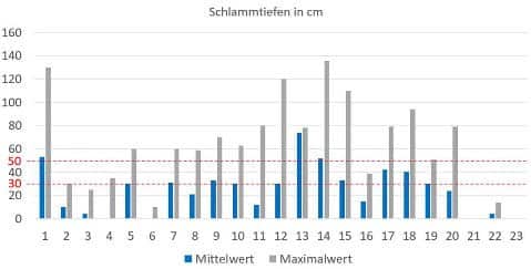
In the author’s assessment, facilities with a sludge depth of 50 cm or more indicate an increased urgency for cleaning, especially if the maximum values are also high, since the buffer or settling function is particularly at risk. This applies above all to critical single-basin facilities without cascaded basins that could compensate for part of the malfunction.
These statistics make no claim to be representative, as the sample could be biased. It is possible that only facilities already suspected of being particularly silted up were surveyed.
In the chart above, facilities 4 to 7 lie one after another in a chain and have very different sediment quantities, which is probably due mainly to the different driving dynamics in the catchment areas (e.g. level sections vs. inclines). As a rule, it is therefore not sufficient to take spot measurements (e.g. at every fifth facility) and then assume that the facilities in between are likely to be similar. In fact, each facility has to be measured individually.
Considering only the facilities that need to be cleaned out, the average sludge volume is 189 m³ per facility.
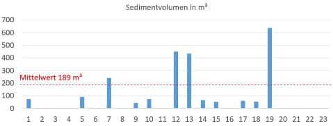
As already explained in Part 1, cleaning is laborious and costly, since the dried sludge usually has to be deposited in special landfills whose fees have risen considerably in recent years due to lack of space. On top of this come the costs of the actual cleaning work.
Comparative data for checking the measurements are hard to find. In summer 2024, however, Autobahn GmbH published a list of measurements for a regional highway section as part of a tender:
| Indicator | Own drone surveys | Autobahn GmbH (tender 2024) |
|---|---|---|
| Total facilities | 23 | 72 |
| with sludge depth ≥ 30 cm | 12 (52%) | 41 (57%) |
| with sludge depth ≥ 50 cm | 3 (13%) | 18 (25%) |
| Average volume | 189 m³ (facilities in need of cleaning) | 148 m³ |
It is not known whether the samples and the accuracy of the measuring methods are comparable, but the agreement with our own results is remarkably good.
Stormwater retention facilities for treating road runoff perform important functions for flood and environmental protection. During heavy rainfall events, they provide temporary storage for the large volumes of water drained from sealed road surfaces, which would otherwise quickly flood the surrounding water bodies. In addition, they prevent pollutants washed off road surfaces, some of them highly toxic such as heavy metals and microplastics, from entering the environment and the wider water cycle.
The pollutants settle as sludge and sediment in the deeper areas of the facilities and increasingly reduce their working volume, which can impair the settling and retention function. The quantities of sludge and sediment must therefore be checked regularly and removed – usually at considerable cost – when specified limits are exceeded.
Along the highways alone there are around 10,000 facilities in Germany, 6,000–7,000 of them with a permanent pool. Inspecting these in particular is often difficult and can then only be done by labor-intensive sounding from inflatable boats.
New developments in drone-based sensors and methods now offer a fast, accurate and economical alternative for the first time, allowing the sediment deposits of a large number of facilities to be checked. Projects carried out throughout Germany by the author’s company in recent years provide a systematic view of the condition of the facilities for the first time, and insights can be derived for more accurate and efficient approaches to sediment determination.
With the Geospector Sludge Check, we survey the sediment surface and bed of your stormwater retention facilities area-wide by drone – without a boat and without the need for an existing baseline survey.
The full article is also available as a PDF download (in German).

