
With our services, you choose the highest possible quality of results and process reliability, even for special surveying tasks.
Our engineering office can look back on over 20 years of experience and guarantees you the highest level of quality in the realization of even the most complex projects.
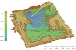
A series of images taken vertically is combined using photogrammetric analysis to create a large-format, rectified and true-to-scale “aerial image”. The accuracy here is in the centimeter range. Elevation models (DEM = Digital Elevation Model), 2-1/2-D and simple 3D models as well as any desired elevation and cross-section profiles can then be derived from this.
Our services are particularly suitable for construction and urban planning as well as for supporting engineering surveys that require a high degree of accuracy.
The generated data can be transferred to your project in a variety of file formats. You have direct and fast access to our data servers so that we can also offer an iterative evaluation process that allows us to react flexibly to your feedback and change requests.

Our complex photogrammetric evaluation enables us to map complex roof landscapes, visualization for architectural projects and many other applications in which complex 3D models create added value for your project. Depending on the application, we provide you with semi-automatically generated point clouds or manually generated meshes. The transfer takes place in any exchange format for direct integration into your CAD systems.
Depending on the application, point clouds (e.g. for organic structures) or textured meshes (e.g. architecture) are more suitable modeling methods. Of course, we offer you both options with comparable quality and accuracy.

Object assessments often have to be carried out in the invisible light spectrum, for which we can also use thermographic, NIR and multispectral sensors. In addition to purely optical sensors, our multicopter systems can also be used as a carrier platform for special sensor technology (e.g. gas, radioactivity, etc.).
As standard, inspection flights are carried out manually with a multicopter in order to be able to react flexibly to situations. In the case of extensive objects or if the flight path is to be flown repeatedly and identically (e.g. for time series), we can also carry out an automatic waypoint flight.

We have a deep understanding of geodetic issues and the associated measurements. Intensive development experience in optical metrology and involvement with selected surveying topics are our basis for quality and accuracy.
Within our engineering office, we have decades of development expertise in individual components and complete systems in a wide range of industries and are happy to think outside the box in order to implement customer requirements in the best possible way.
We love flying and everything that goes with it! We have also flown in “real” airplanes as a hobby in many places around the world and are always having a taste of professional flying. This is an important prerequisite for dealing with flight planning, safety and regulations – also in the field of unmanned aviation.
Our offer for architectural offices and urban planners supports tasks in which high visual quality requirements and surveying precision are of great importance in the work process. Examples of these challenges are
In the run-up to architectural and urban planning projects, photorealistic representations of the planning objects and their surroundings are often necessary. Here we support you from the recording of the surroundings by multicopter or ground-based surveying to the creation of 3D models for use in your planning documents.
Multicopter images offer unique access to the acquisition of basic data, particularly in the area of large-scale, daily updated area images. In conjunction with our ground-based surveying technology, we achieve accuracies in the centimeter range so that the generated orthophotos can be used directly for plan creation and further application within your planning process.
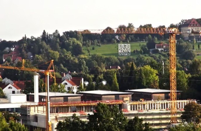
In the planning phase and during construction work, extensive photo and film documentation of the construction site and the surrounding area is often required. The use of a drone or multicopter is ideal for unusual perspectives or difficult-to-access positions in particular – both for one-off shots and for regular documentation series.
We offer our customers in administration and industry, for example in open-cast mining, optimum and flexible integration of our services into their existing workflows as one-off or recurring services:
Especially in large-scale terrain and buildings that need to be recorded on a daily basis, multicopter recordings offer ideal conditions for obtaining the basic data. In conjunction with our ground-based surveying technology, we achieve accuracies in the centimeter range in terms of position and height. The subsequent photogrammetric evaluation provides you with exactly the data you need for your workflow
Multicopter flights are ideal for documentation and inspection activities (industrial plants, buildings, agricultural areas, etc.) from unusual perspectives or hard-to-reach positions. In addition to one-off recordings, we also offer regularly repeated flights in order to obtain time series. The efficient alternative to high tripods or intensive personnel assignments with unusual accuracy.
In addition to classic imaging, multicopters can also use infrared cameras. The near IR range is primarily used to record and categorize vegetation data. The images obtained can then be processed photogrammetrically together with other images. Thermographic images using multicopters are ideal for determining damage to photovoltaic and industrial systems and for detecting heat or cold leaks.

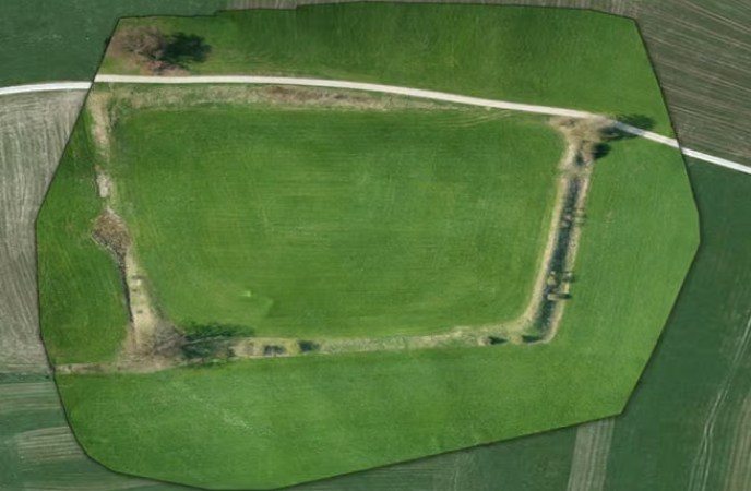
In addition to traditional areas such as archaeology and monument preservation, we offer science and research our entire know-how for in-house developments in order to open up new and challenging areas of application:
Especially in the field of large-scale, daily updated area surveys, multicopter images offer unique access to the data basis. In conjunction with our ground-based surveying technology, we achieve accuracies in the centimeter range so that the generated orthophotos can be used directly for plan creation and further application within your project.
Multispectral cameras can be used in parallel with conventional imaging. Depending on the task, any frequency bands and bandwidths can be combined. The images obtained can then also be processed photogrammetrically.
In addition to image acquisition, multicopters are an ideal carrier platform for the use of any sensor technology (climate, gas, radioactivity, etc.) in places that are difficult to access. Thanks to our engineering expertise, we can offer you customized solutions for your specific project.
Special surveying tasks in particular, where special techniques and innovations are required, are ideal areas of application for our multicopters. In combination with our engineering services, we are able to solve a wide range of challenges:
Multicopter recordings (e.g. for laser scanning) with subsequent photogrammetric evaluation are clearly superior to traditional surveying methods in terms of flexibility and efficiency, especially for large-area objects or increased accuracy requirements. The accuracy is in the centimeter range, so that the data can be ideally combined with your own surveying data.
Tricky surveying tasks are often difficult or inefficient to solve using standard methods. Thanks to our many years of experience and engineering expertise, we can work with you to develop customized solutions for your specific project. The use of our multicopters is not absolutely necessary; we are happy to think outside the box and come up with unconventional approaches.